FLUTEDSHELL MUSSEL

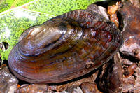
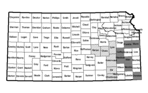
This freshwater mussel is moderate to thin shelled, elongate to quadrate in shape with a size of approximately 6 inches. The interior color is white to iridescent and external color ranges from tan to black with indistinct broad green rays. The shell is covered by small ridges. The species is an obligate riverine species preferring clear water riffles with moderate current on substrate of medium to small sized gravel. Historically occurred in the Fall, Elk, Verdigris, Cottonwood, Spring and Marais des Cygnes Rivers. It still occurs in the same watersheds, but at greatly reduced numbers and distribution.

Flutedshell Mussels are protected by the Kansas Nongame and Endangered Species Conservation Act and administrative regulations applicable thereto. Any time an eligible project is proposed that will impact the species’ preferred habitats within its probable range, the project sponsor must contact the Ecological Services Section, Kansas Department of Wildlife, Parks and Tourism, 512 SE 25th Ave., Pratt, Kansas 67124-8174. Department personnel can then advise the project sponsor on permit requirements.
DESIGNATED CRITICAL HABITATSAs defined by Kansas Administrative Regulations, critical habitats include those areas documented as currently supporting self-sustaining population(s) of any threatened or endangered species of wildlife as well as those areas determined by the Kansas Department of Wildlife, Parks and Tourism to be essential for the conservation of any threatened or endangered species of wildlife.
Currently, the following areas are designated critical for Flutedshell Mussels:
(1) The main stem of the Spring River in Cherokee County (Sec. 1-T33S-R25E) to U.S.66 (Sec.17-T34S-R25E).
(2) Shoal Creek in Cherokee County from the Missouri border (Sec. 36-T34S-R25E) to K-26 (Sec. 35-T34S-R25E).
(3) The main stem of the Neosho River from K-57 in Coffey County (Sec. 33-T22S-R16E) to K-59 in Neosho County (Sec. 6-T29-R20E).
(4) The main stem of Pottawatomie Creek from where it enters Franklin County (Sec. 18-T19S-R21E) into Miami County to the confluence with the Marais des Cygnes River (Sec. 12-T18S-R22E).


