HORNYHEAD CHUB

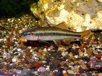
The Hornyhead Chub is one of Kansas’ largest native minnows, attaining a length of 6-8 inches. This fish is quite similar to the more common creek chub. In color, it is dusky to black above and silvery below. It has a large mouth. Adult males have a red spot behind the eye. There is a round blackish spot at the base of the tail fin. The Hornyhead Chub formerly occurred in small to medium sized, moderate to low gradient, clear gravelly streams throughout most of the Kansas River and Marais des Cygnes River basins. It prefers pools and slow to moderate runs and is often associated with aquatic plants. Requires gravel areas free of silt for spawning. Spawns from late April through early July.

Hornyhead Chubs are protected by the Kansas Nongame and Endangered Species Conservation Act and administrative regulations applicable thereto. Any time an eligible project is proposed that will impact the species’ preferred habitats within its probable range, the project sponsor must contact the Ecological Services Section, Kansas Department of Wildlife, Parks and Tourism, 512 SE 25th Ave., Pratt, Kansas 67124-8174. Department personnel can then advise the project sponsor on permit requirements.
DESIGNATED CRITICAL HABITATSAs defined by Kansas Administrative Regulations, critical habitats include those areas documented as currently supporting self-sustaining population(s) of any threatened or endangered species of wildlife as well as those areas determined by the Kansas Department of Wildlife, Parks and Tourism to be essential for the conservation of any threatened or endangered species of wildlife.
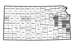
Currently, the following areas are designated critical for Hornyhead Chubs:
(1) The main stem Pottawatomie Creek from its confluence with Cherry Creek in Sec. 7, T21S, R18E, Anderson County to its confluence with the Marais des Cygnes River in Sec. 12, T18S, R22E, Miami County.
(2) The main stem Cedar Creek from its point of entry into the Sec. 1, T22S, R18E, to its confluence with Pottawatomie Creek at Sec. 1, T20S, R19E, Anderson County.
(3) The main stem South Fork Pottawatomie Creek from its point of entry into Sec. 27, T21S, R20E, to its confluence with Pottawatomie Creek at SW Corner Sec. 19, T19S, R21E, Anderson County.
(4) The main stem Elm Creek from its point of entry into the NW/4 Sec. 31, T14S, R12E, Wabaunsee County, into Lyon County through Sec. 3, T16S, R12E.
(5) Locust Creek from its point of entry into NW/4 Sec. 2, T15S, R11E to the confluence of Elm Creek (NE/4, Sec. 7, T15S, R12E) Wabaunsee County.
(6) Hickory Creek from Highway 68 crossing (Sec. 36, T16S, R20E), Franklin County to the confluence of Marais des Cygnes River (Sec. 8, T17S, R21E).
(7) The main stem of Marmaton River in Bourbon County from Highway 3 crossing (Sec. 27, T25S, R22E), into the City of Fort Scott (Sec. 30, T25S, R25E).
(8) Mill Creek from Highway 54 crossing (Sec. 23, T25S, R25E) into the City of Fort Scott, at the confluence of the Marmaton River (Sec. 30, T25S, R25E), Bourbon County.
(9) Pawnee Creek from the south point of entry into Sec. 18, T26S, R24E, to the confluence of the Marmaton River in Bourbon County (Sec. 7, T26S, R24E).
(10) North Wea Creek and tributaries in Miami County from where it crosses the Johnson/Miami county line (Sec. 19, T15S, R25E) to State Highway 68 (Sec. 29, T16S, R24E).


