TOPEKA SHINER

Garold Sneegas
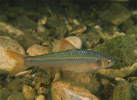
The Topeka shiner is a small minnow, not exceeding 3 inches in length. Silvery-sided with a well- defined dark stripe along the side. The tail fin has a black wedge-shaped spot at the base, other fins are plain. Breeding males exhibit reddish-orange coloration on all fins.
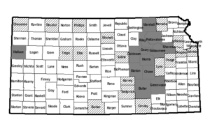
Historically, records show that this species was located in all but the southwest part of Kansas. Now it is mainly found in the Flint Hills in east central Kansas and in Wallace County in the far western part of the state. This species lives near the headwaters of small prairie streams with high water quality and cool temperatures. These streams generally exhibit intermittent flow during summer, however pools are maintained by spring or groundwater percolation. The substrates of these streams are most often clean gravel, however bedrock and clay hardpan overlain by a thin silt layer are not uncommon. Topeka shiners most often occur in pool and run areas.

Topeka Shiners are protected by the Kansas Nongame and Endangered Species Conservation Act, the Federal Endangered Species Act, and state and federal regulations applicable to those acts. Any time an eligible project is proposed that will impact the species’ preferred habitats within its probable range, the project sponsor must contact the Ecological Services Section, Kansas Department of Wildlife, Parks and Tourism, 512 SE 25th Ave., Pratt, Kansas 67124-8174. Department personnel can then advise the project sponsor on permit requirements. Sponsors of project impacting Topeka Shiner habitats must also contact the Endangered Species Specialist, U.S. Fish and Wildlife Service, 315 Houston Street, Suite E, Manhattan, Kansas 66502.
DESIGNATED CRITICAL HABITATSAs defined by Kansas Administrative Regulations, critical habitats include those areas documented as currently supporting self-sustaining population(s) of any threatened or endangered species of wildlife as well as those areas determined by the Kansas Department of Wildlife, Parks and Tourism to be essential for the conservation of any threatened or endangered species of wildlife.
Currently, the following areas are designated critical for Topeka Shiners:
(1) Thurman Creek and its tributaries in Chase County from where it enters the South Fork Cottonwood River (Sec. 28, T22S, R8E) upstream to its headwaters (Sec. 34, T22S, R9E).
(2) Thurman Creek and its tributaries in Greenwood County from where it crosses the Chase/Greenwood County line (Sec. 2, T23S, R8E) upstream to its headwaters (Sec. 20, T23S, R9E).
(3) South Fork Cottonwood River and its tributaries in Butler County from the Butler/Chase County line (Sec. 4, T23S, R8E) upstream to its headwaters (Sec. 21, T23S, R8E).
(4) Mercer Creek and its tributaries in Chase County from where it enters the South Fork Cottonwood River (Sec. 8, T22S, R8E) upstream to the Chase/Butler County line (Sec. 31, T22S, R8E).
(5) Little Cedar Creek and its tributaries in Chase County from where it enters the South Fork Cottonwood River (Sec. 8, T22S, R8E) upstream to its headwaters (Sec. 7, T22S, R8E).
(6) Jacob Creek and its tributaries in Chase County from where it crosses the Chase/Lyon County line (Sec. 36, T19S, R9E) upstream to its headwaters (Sec. 25, T20S, R9E).
(7) Gannon Creek and its tributaries in Chase County from where it enters Diamond Creek (Sec. 10, T19S, R7E) upstream to its headwaters (Sec. 11, T18S, R7E).
(8) Schaffer Creek and its tributaries in Chase County from where it enters Diamond Creek (Sec. 19, T18S, R7E) upstream to its headwaters in Morris County (Sec. 28, T17S, R7E).
(9) Collett Creek and its tributaries in Chase County from where it enters Middle Creek (Sec. 18, T19S, R7E) upstream to its headwaters (Sec. 27, T18S, R6E).
(10) Cary Creek and its tributaries in Dickinson County from where it crosses the Dickinson/Geary County line (Sec. 6, T14S, R5E) upstream to its headwaters (Sec. 33, T15S, R3E).
(11) West Branch Lyon Creek and its tributaries in Dickinson County from where it enters Lyon Creek (Sec. 2, T15S, R4E) upstream to its headwaters (Sec. 16, T16S, R3E).
(12) North Elm Creek and its tributaries in Marshall County from where it enters the Big Blue River (Sec. 14, T1S, R7E) upstream to its headwaters (Sec. 19, T1S, R9E).
(13) Mulberry Creek and its tributaries in Morris County from where it enters Six-mile Creek (Sec. 21, T17S, R6E) upstream to its headwaters (Sec. 25, T17S, R5E).
(14) Clear Fork Creek and its tributaries in Pottawatomie County from where it crosses the Pottawatomie/Marshall County line (Sec. 2, T6S, R9E) upstream to its headwaters (Sec. 28, T6S, R10E).
(15) Deep Creek main stem in Riley County from where it crosses the Riley/Wabaunsee County line (Sec. 22, T10S, R9E) upstream to Interstate Highway 70 (Sec. 25, T11S, R9E).
(16) Mission Creek main stem in Shawnee County from where it crosses State Highway 4 (Sec. 9, T12S, R14E) upstream into Wabaunsee County through Sec. 2, T13S, R12E.
(17) Mill Creek and its tributaries in Wabaunsee County from where it crosses Interstate Highway 70 (Sec. 27, T11S, R11E) upstream to where it crosses State Highway 99 (Sec. 26, T13S, R10E).
(18) Mulberry Creek main stem in Wabaunsee County from where it enters Mill Creek (Sec. 25, T11S, R11E) upstream to its headwaters (Sec. 6, T11S, R11E).
(19) Willow Creek main stem in Wallace County from where it enters the Smoky Hill River (Sec. 17, T13S, R41W) upstream through Sec. 3, T13S, R41W.
Numerous main stem and tributary reaches of: Rock Creek, Sharpes Creek, Bloody Creek, Crocker Creek, Fox Creek, Diamond Creek and Middle Creek in Chase County; Lyon Creek in Dickinson County; Davis Creek, Thomas Creek and Dry Creek in Geary County; Mud Creek and Middle Creek in Marion County; Diamond Creek in Morris County; Walnut Creek, Wildcat Creek, Little Arkansas Creek and Seven-mile Creek in Riley County. Detailed maps showing specific designated stream reaches in these counties are maintained in the Ecological Services Section, Pratt Operations Office.


